![]()
Not long after the invention of the telescope in the 1600s, astronomers on Earth could see white polar caps on Mars. These hinted that Mars had at least some water in the form of snow or ice. (At the time, CO2 ice was not even considered as a possibility.) The caps dramatically expanded and shrank as seasons passed, which suggested the amount of water was not great. But astronomers had no way to measure how much or how little water was involved. Soon the idea of a planet-wide desert took hold among scientists and public alike. (Countless science-fiction stories, novels, and movies have used this Mars as a background. See Ray Bradbury's The Martian Chronicles, for example.)
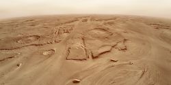
Compared to Earth, Mars really is a planet-wide desert. If you stand on the Martian surface almost anywhere except near the polar caps, the surface underfoot will be far drier than the driest desert on Earth. (That's the Atacama Desert in Chile, where the yearly rainfall averages less than 15 millimeters, or roughly half an inch.)
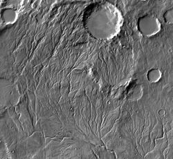
However, since the mid-1960s, Mars scientists have collected a wide variety of digitized data from many spacecraft carrying sophisticated instruments. These data show that Mars has a large amount of water currently, mostly frozen. In addition, orbital images of geologic features such as outflow channels and valley networks strongly suggest that Mars has been much wetter in the past. Like Earth, Mars today has four known sources, or "reservoirs," of water, according to scientists. One is the atmosphere, which holds a bare trace of water vapor. The second are the ice-rich layers in the polar caps and regions. The third lies underground in the subsurface.
Scientists can measure the amounts of water in the first two sources. But the third reservoir, the subsurface, can only be estimated from how much water was needed to erode visible geologic features.
The biggest uncertainty, however, lies in the fourth reservoir: the water chemically locked up in rocks and minerals such as clays. Some research suggests this could hold as much water as the other three reservoirs combined. But no one knows for certain, because scientists don't know the full extent of such "hydrated" minerals. This is an area for much future work.
So how much water exists today on Mars? When discussing amounts of Martian water, past and present, scientists use a term such as global equivalent layer (GEL) or similar words. This is the thickness an amount of water would have if it were spread evenly over all of Mars. Taking what can be detected directly by spacecraft, scientists estimate that the measurable total of Martian water — in other words, its hydrosphere — is about 30 meters (100 feet) GEL. Nearly all of this lies in the polar caps and region. (Atmospheric water contributes only a negligible trace.)
As for the subsurface, current technology cannot measure how much water is there. Based on geologic features, scientists estimate 500 to 1,000 meters (1,600 to 3,300 ft) GEL could exist, but the subsurface quantity of water is only a very rough estimate. No one knows how deep ground ice and groundwater go.
An average GEL value is useful in thinking about Mars in global terms. But it is important to remember that Mars has lost water since it formed through the loss of its atmosphere due to erosion by the solar wind and energetic particles. Thus the current total is less than what Mars had when it formed. Also, local parts of Mars — the northern lowlands, for example, or the outflow channels — have seen a lot more water than average, at least for brief periods in the distant past.
The underground reservoir of water, according to scientists, is sealed in place by the cryosphere. This is a global layer of permanently frozen ground. (Earth has a similar layer called permafrost, mainly in the Arctic and Antarctic regions.) Scientists calculate that the Martian cryosphere reaches to depths of about 2.5 kilometers (1.5 miles) near the equator and to about 6.5 km (4 mi) in the polar regions.
Much of the cryosphere is rich in water ice, scientists think. Yet what defines the cryosphere is that its temperature never rises above freezing — 0° Celsius (32° Fahrenheit) — all year round. Although the surface of Mars often falls well below freezing, in many regions solar heating warms the topmost layer of surface soil above 0° C during part of the day. When this happens, any water or ice caught in the soil will sublimate, becoming water vapor. It will then escape into the atmosphere. This process soon creates a surface layer of dry ("desiccated") soil. How deep the dried-out surface layer goes in a given location depends on how warm it gets and for how long. This in turn depends in part on topography, but mostly on latitude. In polar regions, the dry soil layer remains thin, and the water ice lies just below the surface.
In 2008 the Phoenix lander set down at latitude 68° north. It scraped away about two inches of dry dirt and found a frozen mix of whitish water ice and reddish-brown soil. Exposed to the air and sunlight, the ice immediately started to sublimate — it evaporated directly into a gas as opposed to what we are familiar with on Earth, where ice goes from a solid to a liquid then to a gas (vapor).
Shifting attention from the polar regions to the warmer equatorial regions, scientists think that the ice layer will be found deeper, upwards of a kilometer (half a mile) or more. Why is this important? Because the cryosphere is a barrier. It keeps any liquid groundwater from reaching the surface and spilling out. Viewed another way, anything that cracks that barrier — a meteorite impact, volcanic activity, or geological faulting — opens the way for any local groundwater to escape onto the surface. Many scientists hypothesize that the valley networks and outflow channels both point to a warmer, wetter period in the Martian past when water could flow across the land.
A Martian atmosphere like today's is too thin and cold for that to happen. But scientists also hypothesize that Mars had a thicker atmosphere early in its existence — as dense as Earth's is now or denser. This would have made the surface warmer and allowed flowing water, lakes, and perhaps even oceans.
How much wetter was ancient Mars? Estimates range from 600 to 2,700 meters (2,000 to 8,900 feet) GEL — many times today's value. Mars therefore appears to have lost most of its initial water to space. What caused the loss, scientists think, was the shutting down of Mars' magnetic field. This is generated (like Earth's) by currents of molten iron flowing around the core. But for unknown reasons, the Martian magnetic field faded and ceased by around 3.7 billion years ago. Turning off the magnetic field allowed the Sun's wind of energetic particles and extreme ultraviolet light to strip away the atmosphere — and with it went vast amounts of water.
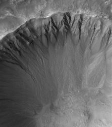
The end product was today's thin, cold atmosphere. NASA's new Mars mission MAVEN, due for arrival at Mars in September 2014, is designed to measure how fast Mars is losing water and other volatile gases. At present Mars is a planet-wide desert with no bodies of open water. And yet amazingly, liquid water does appear to flow on the surface today, although only in small amounts, in just a few places, and under special conditions. Recurring slope lineae were discovered using images from the HiRISE camera on NASA's Mars Reconnaissance Orbiter.
The lineae are finger-like dark lines that form in the middle southern latitudes on slopes that face north (toward the Sun) and which are steeper than 25°. The dark lines appear and crawl slowly downhill during southern spring and summer. Then they fade and disappear over winter. HiRISE has imaged them recurring in the same places for several Martian years. While scientists have not identified the chemical composition of the minerals in these flows, they expect brines — water containing salts that lower the freezing point — will be the likely source.


